|
|
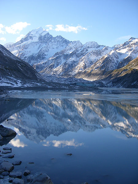 At
3,754m Mount Cook (its Maori name is Aoraki) is New Zealand's highest
mountain. Nudging one side of Mt Cook is the mighty Tasman Glacier, one of
the longest outside the Himalayas. At
3,754m Mount Cook (its Maori name is Aoraki) is New Zealand's highest
mountain. Nudging one side of Mt Cook is the mighty Tasman Glacier, one of
the longest outside the Himalayas.
Aoraki/Mount Cook National Park (70,696 hectares) is New Zealand's great
alpine park. It has the highest mountains and the largest glaciers.
Aoraki/Mount Cook Village and all visitors to the park are dwarfed by the
immensity of the landscape that surrounds them.
Mount Cook/Aoraki National
Park was formally established as a national park in 1953 from reserves that
were established as early as 1887 to protect the area’s significant
vegetation and landscape.
Mount Cook/Aoraki National Park is located in the central part of the South
Island, deep in the heart of the Southern Alps.
Mount Cook/Aoraki National Park is a harsh land of ice and rock. Glaciers
cover 40% of it. There are 19 peaks over 3,000 metres including of course
New Zealand's highest mountain, Aoraki/Mount Cook. The park is also part of
Te Waipounamu - South Westland World Heritage Area in recognition of its
outstanding natural values.
The glaciers that have helped shape the park's landscape include five major
valley systems: Godley, Murchison, Tasman, Hooker and Mueller. The Tasman
Glacier, New Zealand's largest and longest glacier, is clearly visible from
the main highway at the entrance of the park.
Aoraki/Mt Cook village is located on the southern slopes of Aoraki/Mount
Cook, 12 kilometres south of Aoraki/Mount Cook's summit. It is located to
Lake Pukaki by Highway 80 and to the face of the Hooker Glacier, on the
upper reaches of the Tasman River.
The village serves as a
tourist centre and base camp for mountaineers, and lies within the borders
of Aoraki/Mount Cook National Park. The Hermitage, the name of which dates
back to the original hotel built in 1884, is a prominent and popular
location in the village, and is sometimes used as an alternative name for
the settlement. The nearest town to Aoraki/Mount Cook village is
Twizel being 35 kms away.
Aoraki/Mount Cook village is an
easy five-hour drive from
Christchurch or
Queenstown. On the way you will pass
Lake Tekapo on whose shores is the stone
Church of the Good Shepherd which has a spectacular view of the Southern
Alps framed by its altar window and
Twizel.
Aoraki/Mt Cook National Park and
the village is served by daily
bus and coach services from
Queenstown,
Wanaka and
Christchurch.
There is no schedule air services from Christchurch or Queenstown to Aoraki/Mt Cook National Park.
There are no passenger train or rail services from Aoraki/Mt Cook National Park to
Christchurch, Dunedin, Invercargill, Twizel, Oamaru, Tekapo, Wanaka or Queenstown.
|