|
|
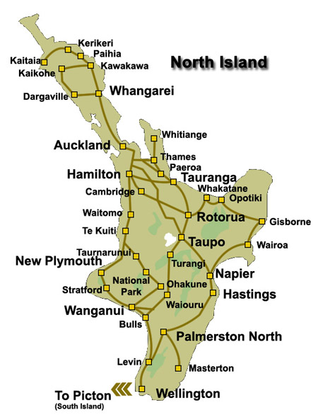 The
North Island (Māori: Te Ika-a-Māui) is one of the two main
islands of New Zealand, separated from the
South Island by Cook Strait. The
North Island (Māori: Te Ika-a-Māui) is one of the two main
islands of New Zealand, separated from the
South Island by Cook Strait.
The North Island is 113,729 square kilometres (43,911 sq mi) in area,
making it the world's 14th-largest island.
It has a population of 3,450,800 (June 2014 estimate).
Eight important cities
are in the North Island, notably New Zealand's largest city, Auckland,
New Plymouth, Tauranga, Gisborne, Napier, Hamilton, Palmerston North and
Wellington - the capital, located at the southern extremity of the
island.
Approximately 76% of New Zealand's population lives in the North Island.
The highest mountain in the North Island is Mount Ruapehu (2,797 metres
(9,177 ft))
According to Māori mythology, the North and
South Islands of New Zealand arose through the actions of the demigod
Māui.
Māui and his brothers were fishing from their canoe (the South Island)
when he caught a great fish and pulled it from the sea. While he was not
looking his brothers fought over the fish and chopped it up.
This great fish became the North Island and thus a Māori name for the
North Island is Te Ika-a-Māui (The Fish of Māui). The mountains
and valleys are said to have been formed as a result of Māui's brothers'
hacking at the fish.
Until the early 20th Century, an alternative Māori name for the North
Island was Aotearoa. In present Māori usage, Aotearoa is a collective
name for New Zealand as a whole.
The North Island is made up of six unique geographical regions ranging
the northern temperate kauri forest regions to the volcanic plateau in
the centre of the islands to the farming landscape to the south of the
island, including New Zealand's longest River - the Waikato River.
The North Island has its own natural scenic beauty and popular tourist
activities include sightseeing, adventure tourism, such as Bungee jumping, tramping (hiking), kayaking, and camping. Numerous
walking and hiking paths in the the many National Parks including the famous
Tongariro Crossing hike locate in North Island's volcanic plateau,
(often called the Central Plateau and occasionally the
Waimarino Plateau), that covers much of central North Island
of New Zealand with volcanoes, lava plateaus and crater lakes home to
Mount Tongariro, Mount Ngauruhoe, and Mount Ruapehu.
The North Island has two major world class skifelds -
Whakapapa Skifield located near
National Park and
Turoa Skifield located near
Ohakune.
These skifields are located on the slops of Mount Ruapehu and can reach
by regular train and bus/coach services from most locations in the North
Island.
The North Island has 4 major national parks, being
Te Urewera Conservation Park,
Tongariro National Park, Whanganui National Park and Egmont National
Park. |